Representative End User Clients







Representative Automation Clients







Representative Software Clients









The Internet of Things (IoT) is all about connecting physical “things,” with each other and with software applications for data acquisition, analytics, and visualization. In the industrial, agricultural, and transportation worlds, identifying the location and monitoring the condition of critical things, or assets is emerging as a key application for IoT.
As recent ARC Advisory Group research indicates, drones or unmanned aerial vehicles (AEVs) are proving to be very useful for  identifying where certain types of “things” are and their condition. This is particularly true for things that move, span large distances, change frequently, or are located in difficult-to-access or hazardous areas.
A variety of suppliers are releasing innovative drone-based solutions to help agricultural, industrial, and commercial companies, as well as government entities, monitor the location and condition of their physical assets or other “stuff.” This ARC Insight will explore some of the diverse applications in which drone technology is playing an increasingly important role.
Applications that require drones to fly in industrial settings have their own unique legal, environmental and technical problems. Many, but not all relate to government regulations such as the FAA regulations in the US. For example, to fly into an environment in which flammable conditions exist, drones must meet specific electrical classifications. Refineries, gas plants, oil rigs, chemical industry, and other industrial facilities have classifications for hazardous environments like Class 1 Div 2. So far, we have not seen intrinsically safe-rated drones, although some companies are working on this.
Much of the credit for the success of many drone-related applications must go to the drone-mounted digital devices that collect visual and other data. Very capable cameras are within the payload range of even small drones. Some cameras operate in multispectral ranges, from infrared to ultraviolet. Drones can also carry other devices that allow precise physical asset location and/or the condition, as well as environmental conditions. Consider that while gas leaks are hard to see with the naked eye, IR sensing cameras can identify leaking hydrocarbons, carbon monoxide, or carbon dioxide.
Support for “digital” farming has emerged as the largest single application for commercial or industrial drones. Many companies take an inventory of their physical assets every year but, for farmers, the most precious “assets” are the plants they grow in the fields. Every single plant is an asset and farmers need to monitor their assets often and act quickly on their condition, as needed.
A farmer can only gain so much actionable intelligence by walking up and down rows of vegetables or fruit trees and making 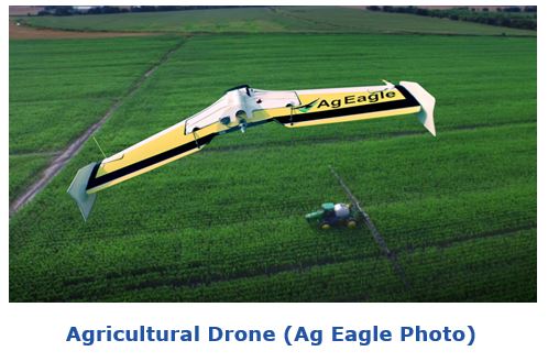 observations with a clipboard. While large-scale farmers have been using satellite imagery and have sensors on tractors and farm equipment; drones equipped with multispectral cameras, LIDAR, and GPS have brought actionable intelligence to a new level.
With this technology, a farmer could make a new drone flight every few days for the whole growing season. This would enable him/her to identify the location of every single plant or tree and identify its condition to determine plant health, insect damage, and soil moisture and predict crop yields.
Analysis tools are emerging to enable the farmer to use that drone-derived intelligence for precise recommendations on applying fertilizer and insect treatments, and watering and subsequently monitoring the results. By incorporating National Weather Service-provided data about rainfall and sunlight, the farmer could further refine his or her actions.
While it’s not likely that the average farmer could pull together all elements of this digital farming approach, many have found third-party service partners that can help do so.
In this type of digital farming application, drones are more precise than satellite imagery; can gather data faster than sensors attached to a tractor, and are both less expensive and less intrusive than hiring a helicopter pilot to collect the data.
On private farmland in rural areas, drones could fly at low altitudes, avoiding some of the safety issues of most concern to the FAA. Many agricultural missions for drones could operate within the simple, low-cost Part 107 rules. However, even if the drone missions require more stringent FAA Section 333 permits for flying beyond line of sight, at night, carrying more than 55 pounds, etc. FAA is much more likely to issue a permit for rural applications like farming, than for urban applications such as those envisioned by Amazon.
Todd Chase, Aviation Safety Manager at Oceaneering International, gave an interesting presentation on drone applications in upstream oil & gas at ARC’s recent Industry Forum in Orlando, Florida. He stressed that it is important to focus on the data collection, rather than worry about what kind of drone to use.
Mr. Chase mentioned that, in upstream oil & gas alone, drone data gathering applications include:
 Drone applications span military, industrial, commercial and personal sectors. The military and space programs have developed the most sophisticated drones and the systems to control them. Some military drone suppliers also provide drones for commercial and industrial applications. Almost any aircraft can be converted to a drone and remotely operated. Taking the human pilot out of the aircraft allows drone designs to develop in directions that would not be practical for manned aircraft.
Steven Lux, Associate Director at the FAA’s National Center of Excellence (COE) for Unmanned Aircraft Systems says that this COE has been working as an industry interface between the FAA and many industry stakeholders. The UAS Center of Excellence has executed several studies on safety issues, drone collisions, flight risks, and drone maintenance.
Industrial drone usage is about gathering data and using the data to develop actionable intelligence. Drone-based data collection requires mission planning and execution that meets both safety and legal standards.
Suppliers looking to enter this market space must have expertise in multiple disciplines. While it is not so difficult to identify the location of physical assets, assessing the condition of those assets requires specific technologies appropriate for that mission and environment.
End user organizations looking to gather data with drones should consider the following:
If you would like to buy this report or obtain information about how to become a client, please Contact Us
Keywords: Unmanned Aircraft Systems, Unmanned Aerial Vehicles, Drones, Industrial Internet of Things (IIoT), Oil & Gas, Energy, Digital Farming, Safety, Emerging Technology, Robotics, ARC Advisory Group.